
 Home
Home Author
 History
 Credits
 Home
Home Contact
 Change Log
 Index
Index Alphabetic
 Finished Albums
 Maps
Maps AZ Gmap
 AZ
AZ Physical Ability
 Raw Albums
 Vehicle Type
 Resources
 BLM/FS
 Equipment
 Needed
 Suppliers
 Fossils
 Rock ID
 Tips
Tips Ethics
 Health
 Safety
 Trip Types
 Members
 Login
Login Logout
 PW Change
 PW Forgot
 Renewal
Material Found Site Photos Download Photos GPS Waypoints
Topo Maps: Overview Overview Legs Leg 1 Leg 2 Leg 3 Leg 4
| Trip Name | Site GPS Coordinates | Trip Area |
|---|---|---|
| Rye Creek | Site 1: 34.14680, -111.41047 |
Northeast |
| Vehicle Type | Physical Ability | Season |
| Any | Easy | Sep - Jun |
Trip Description:
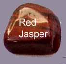
This collecting area is located at an altitude of about 3600 feet so the temperatures are usually 5 to 10 degrees cooler than the Phoenix area. The three sites all located at crossings of Rye Creek are all abundant with the red and black Jasper in sizes up to something requiring mechanical assistance. I did not stop at every crossing of the creek but did slow down enough to see that every crossing looked promising. I also noticed interesting material along the sides of the road near all of the Creek crossings. I'm told that the source of this beautiful Jasper is located at the end of the track that goes to the left at the third site. (See site Photos) I was not able to investigate this location as I was did not have my ATV which would be highly recommended for exploring the source of the material. I was not disappointed as the material that is available is both plentiful and of good quality for making stunning jewelry. I found the best material at the site marked number two on the topo maps. The rock trip ends at site number three however Forest Service Rd., #414 continues north through the forest for another 11.5 miles and enters Payson, AZ and from the West. If you're interested in completing this segment then see the Rye Creek to Payson Backcountry Trip.
Best Time to Visit: September to June
Trips in this Region:
Nearby Attractions:
Mount Ord Mazatzal Wilderness Payson, AZ
Trip Directions:
The left turn off Of Arizona Hwy., #87 which is known as the Beeline Highway is located 10.8 miles South of the intersection with Arizona Highway 260 in Payson Arizona. Coming from the Phoenix area the turn is 62.3 miles North of the intersection of Arizona 87 and loop 202 North. Be sure to check the weather before attempting this trip as the track is composed of fine silt that could be impossible to navigate in wet conditions. I have made the trip during dry conditions without having to use my four-wheel-drive however I had to make sure that I did not slow down when the sandy silt got to deep. The detail waypoints begin at this left hand turn. The first site is located 6.9 miles after the left turn onto the H Bar Ranch Road which becomes Forest Service Rd., #414. The second site is located about .4 of a mile beyond the first site. The third site is located about .5 of a mile beyond the second site. The total distance from the left hand turn to the third site is about 7.8 miles of very dusty track.